


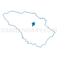
Howard Precinct 03-004, Howard County, Maryland
About
Outline

Summary
| Unique Area Identifier | 592523 |
| Name | Howard Precinct 03-004 |
| County | Howard County |
| State | Maryland |
| Area (square miles) | 2.04 |
| Land Area (square miles) | 2.03 |
| Water Area (square miles) | 0.00 |
| % of Land Area | 99.80 |
| % of Water Area | 0.20 |
| Latitude of the Internal Point | 39.27718130 |
| Longtitude of the Internal Point | -76.89460240 |
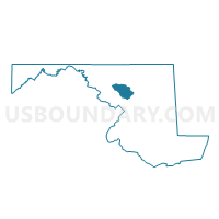
Maps

Graphs
Select a template below for downloading or customizing gragh for Howard Precinct 03-004, Howard County, Maryland


Neighbors
Neighoring Voting District (by Name) Neighboring Voting District on the Map
- Howard Precinct 02-017, Howard County, MD
- Howard Precinct 03-001, Howard County, MD
- Howard Precinct 03-003, Howard County, MD
Top 10 Neighboring County Subdivision (by Population) Neighboring County Subdivision on the Map
- District 2, Ellicott City, Howard County, MD (62,697)
- District 3, West Friendship, Howard County, MD (15,786)